
Winter is supposed to be cold up here in the frozen North. November? Not so much. But the patterns that have brought unbelievably cold air directly from the Arctic and lifted Lake Erie into a frozen cloud that buried Buffalo are abating. Next week should be warmer, and the weeks after that perhaps better as well.
The reason? The Jet Stream, which has been hardly functioning for many years, appears to be re-forming. There is always a lot of speculation as to why, without a lot of solid assurances, but the trend is our friend. Let’s hope that what we see coming next week becomes the pattern.

Eight feet of snow in three days could not have been fun.
We have to start with why there is a Jet Stream in the first place. It’s a strong Westerly wind that washes over the Northern Hemisphere. The exact placement of it determines who is on the cold side of a winter (to the North) and on the warm side (to the South).
It comes from the way our planet rotates and heats up. In the tropics, there is a strong Easterly wind. That’s not because the air is moving, but the planet is. The rotation of Earth passes under the blanket of air that keeps us all breathing and warm to the East and the air slides over it. The tropics are also where most of the radiation from the sun is absorbed, so the prevailing wind comes in a bubble of expanded, warm air.
That air is also wet from the ocean evaporation that is picked up along the way, starting the cycle of water that keeps our planet alive.
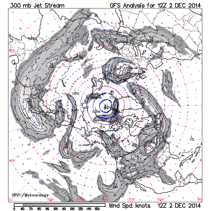
The Jet Stream on 2 December, 2014. There is … something … there.
At higher latitudes, the earth is spinning much slower – in fact, it isn’t moving to the east at all by the North Pole. Where the prevailing drag off of the planet is not important the net outflow from the warm wet bubble out of the east curls around and becomes a Westerly wind, balancing out the air at the tropics. When everything is smooth it keeps going in a constant ribbon.
But that hasn’t been happening, at least since 2012. There hasn’t been a strong Jet Stream for a long time, opening up North America to a periodic flow from the North as colder, denser air rushes in to fill the void where normal circulation would have kept it out.
There has been a Jet Stream, at least at times, as we moved into our long, lingering Fall. It’s starting to re-form strongly and will dominate our continent for at least a week before moving on. As the kinks and wobbles work their way around the Hemisphere it could become cold again, but if the Jet Stream forms strongly we might be in for a warm Winter not seen since 2011-2012. That was the year that the Arctic Ice sheet nearly fell apart.
What has changed since then? For one thing, the sun became dormant. It’s never clear just how that affects the planet, but it is reasonable that it takes a few years for the circulation to re-form. We have been in a weaker sunspot cycle than those for 100 years since 2010, so there are changes.
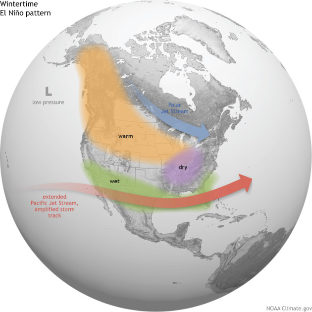
How El Niño affects the airflow, and thus the weather, in North America.
And then there is El Niño. This is the mysterious bubble of warm water that comes out of the Eastern Pacific and travels Westward along the Equator. What causes this remains a mystery, but it’s clearly a big part of how Earth stores and releases heat in the vast reaches of the ocean. An El Niño, which we may see this year, is a strong release of heat that might yet restore the Jet Stream and give us milder weather.
What will the Winter bring? The short answer for longer term trends is that what we see today should hold. But we are in a rapidly changing atmosphere right now where just about anything can happen.
You can chalk it all up to global warming if you want, but I am far more fascinated with sunspot cycles and the natural rhythms of this planet. They aren’t well understood yet, and before we talk about how much heat we are trapping it’s good to know how much heat is coming in. The systems of solar input, greenhouse effect, water cycles, and recirculation are extremely complex and not well understood at each step.
And so it will remain that everyone talks about the weather but no one does anything about it. In the Minnesota milieu of polite conversation we will have a lot to talk about this year, and it will be unusually fascinating.

Thanks for a very informative post. I moved from Indiana to Kentucky for several reasons but one of them being last winter and the frigid and constant temperatures of frigid, along with over 100 inches of snow
I didn’t know it snowed that much in Indiana! Wow. Minnesota is a bit ridiculous, and you never know from one day to the next what will happen. But this year is especially weird. Fall was just great, November was horrible.
I think you are being too optimistic again. 🙂 But as always I hope you are right. This early cold has been a pain literally.
It is always optimistic to think that we can look ahead to anything happening out here on the prairie, but a return to the “zonal” jet stream flow we enjoyed in October is a really good sign. We have to take it. 🙂
It does just get cold in november sometimes, you know. 🙂
True. And it does just get warm in the middle of Winter at random, too. 🙂
You don’t need a weatherman to know which way the wind blows.
That’s why we insist that they tell us what the weather will be tomorrow – it’s much harder and takes a pro. And with all the real-time data we can collect on the economy, it doesn’t take an economist to tell us where we are at today – so …. do they want to still have jobs or not? 🙂
Pingback: Winter Arrives? | Barataria - The work of Erik Hare